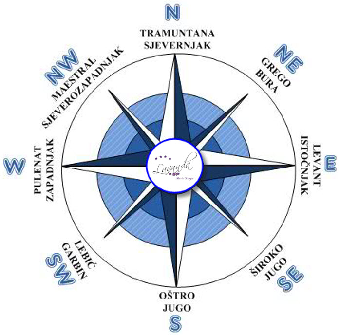
Tramontana is a cold, dry wind that descends from the mountains of the northern of the Mediterranean and the Adriatic coast. On the Adriatic, they blow like a bore, but more from the northern part, and in the area of the island of Pag it turns a little towards the northwest, and never reaches the strength of a storm. It is accompanied by clear weather. Farther from the coast, it is stronger and creates big waves.
Bura – NE Bura is a typical wind of the cold period; it blows from the northeast quadrant, it is predominantly in the northeast direction. It blows from the mountains of the coastal belt and carries cold, dry air, so it feels very unpleasant like an icy wind. They blow in extremely violent gusts, which are called refuli. There are two types of storms: a clear or anticyclonic storm, known for stormy and even hurricane-like (over 118 km/h) wind gusts, formed during dry and clear weather at high pressure, and dark, storm or cyclonic squall, also strong enough to reach the Italian coast, accompanied by cloudy and rainy (even snowy) weather. Low clouds of a uniform color are rising from the southwest, and the pressure is falling. The storm crashes very steeply into the sea, which is smoking, because the wind disperses the droplets from the waves. In the canals, storms are dangerous for smaller ships and boats because sometimes they can appear suddenly, almost without any warning, and immediately blow with hurricane force. Bura blows along the entire coast, it can be especially strong in winter. It also blows in the summer months, but it is not as strong and has a shorter duration.
Jugo – SE jugo is one of the winds on the Adriatic that blows all year round, from the southeast. Jugo usually appears with rainy and cloudy weather, but it can also blow in clear skies. These are two types of south, which differ in origin as well as in weather characteristics. The south with clear skies is called anticyclonic, while the south with wet weather is called cyclonic. The cyclonic south is a warm and humid wind. They blow from the ESE and SSE directions. It can be stormy and even hurricane-force. It develops high sea waves. The sky is covered with thick and very low clouds, and it often brings heavy rain. On those days, our Dalmatians are in a bad mood. In summer, jugo usually lasts no longer than three days, and in winter it can last up to ten days, and sometimes with minor interruptions, up to three weeks. Despite all the strength and long duration, the southerly wind on the Adriatic is not as dangerous as a gale. The South does not appear suddenly like a gale and blows without gusts, so sailors can take shelter in the harbors in time.
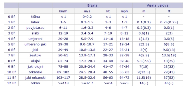
Maestral– NW – (SZ) – Maestral is a typical wind of the summer period on the Adriatic. They blow predominantly from the west or northwest direction. In some localities, depending on the configuration and position of the islands and channels, they blow from the west-northwest direction. The wind is in good weather where the sky is clear and the temperature is pleasant. The summer mistral of good weather blows regularly every day. It starts between 8 and 9 a.m., is strongest around 2 p.m., and ends around 6 p.m. or at sunset at the latest. It usually blows as a moderate wind of 3 to 5 Beaufort, so it is an ideal wind for sailing.
Neveres and neverinis – In addition to local winds, local and short-term weather storms of smaller scale – neveries or neverinis – appear on the Adriatic. They appear in all seasons, but more often in the summer part of the year. Bad weather is characterized by fierce and dangerous gusts of wind (up to 15-40 kt), and usually heavy rain, hail and thunder, and a drop in temperature. They are more often from the west and north-west direction.
