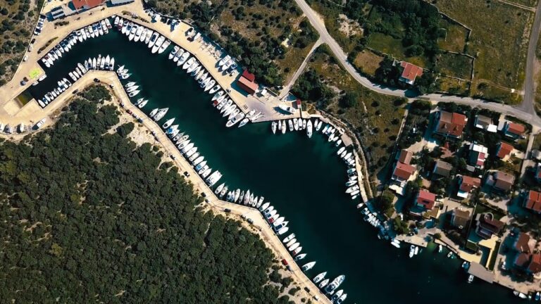
If you have decided to spend 7 days on a sailboat and for that you have chosen Pag, ACI marina Šimuni as the departure port, in this text we will show you interesting ports and bays. And since the ACI marina Šimuni is located between the “northern” and “southern” parts of our coast, we have divided this view into 2 parts and will call them the NORTHERN route and the SOUTHERN route.
The southern route includes one National Park (Kornati) and one Nature Park (Telašćica-Dugi Otok). Apart from these 2 pearls of nature, the area is full of small islands, numerous bays and small villages. As well as larger cities such as
Zadar and Šibenik
Day 1 (Saturday) ACI marina Šimuni-Island Maun or Olib – 3-9 NM
Depending on the time of your arrival at the base on Saturday, after completing the shopping and paper part of taking over the boat and if the weather conditions are favorable, you can sail to Šip bay on the island of Maun, which is 3NM away from ACI Marina Šimuni. In that short time, you can get to know the boat a little better and check whether all the equipment is working properly. And if you want even more. You can sail to Olib in an hour. Slatinica, Draga or the port of Olib. All these are bays where you can find a mooring depending on the weather forecast.
MOORING:
You can anchor on the island of Maun, the bottom is muddy and holds the anchor well. It is a good shelter for winds from the NW and NE direction, but if the wind blows from the S direction, it is better to look for a mooring at the nearby Olib.
On the island of Olib, we recommend Slatinica cove on the E side of the island, where 15 buoys have been placed. The cove with turquoise sea and sandy beach is considered by many to be one of the most beautiful in this part of the Adriatic Sea. But be careful, Slatinica bay is completely open to winds from the N direction, so it is better to sail somewhere else if the forecast is bora or tramontana.
Draga bay on the N part of Oliba can be a good shelter from the storm. A beautiful bay, with turquoise sea and sandy bottom. It is anchored at a depth of 2-5 meters. The anchor holds well on the sandy bottom. The bay is open to the wind from the NW direction. If you expect the wind to strengthen from that direction, it is better to change the place of mooring.
A good alternative to all these bays can be the port of Olib. Located on the W side of the island. There is room for 17 boats. Moorings and berth on the side. The place has a shop and a couple of restaurants and cafes. It is a good shelter from all winds except NW winds.
Day 2 (Sunday) Olib-Rava – 25NM
After a morning swim, sail south. Let our next place be the island of Rava. A small island in the immediate vicinity of Dugi Otok, which in its bays offers many opportunities for mooring. The entire island has a total of 15 bays, which considering the size of the island is a really large number. We recommend those bays closer to Dugi otok.
Navigation:
In order to reach Rava, we have to sail along other islands, because this area is known for a large number of smaller and larger islands, and the distances between individual islands are so small that every hour you can be on another island or bay. Let our route take us to the Zapuntel pass. The Zapuntel passage is a channel that passes between the islands of Ista and Molat. There is enough depth in the passage, only in the narrowest part a little more caution is needed because Ist and Molat have come closer here to a distance of only 50m. In the passage on the left and right side, it is possible to find a mooring and be well sheltered even from the gale that blows strongly in the passage itself. We continue sailing along the W side of the island of Molat, where after Cape Bonaster we enter the archipelago, which is closed by Dugi Otok on the SW side.
It’s time to swim, so make up your mind and look for a beautiful bay just for you on Dugi Otok or Zverinac. We recommend a small lagoon consisting of the islets Planatak Veli, Planatak Mali and Dugi Otok. After swimming, you still have about an hour to reach the island of Rava, where you can choose the bay according to your wishes.

MOORING:
There are anchored buoys in Lokvina bay. The bay is blocked from all winds except SE.
In the bay of Marinica, you can moor at the concrete jetty, a little further from the ferry dock. Depth next to the pier 3m. Anchoring in the bay is not allowed. The place is also called Vela Rava. Restaurant, shop. If the wind increases, you should leave the bay and sail to the neighboring Paladinica bay, where the buoys are anchored.
A little further south is Grbavac cove where there is a restaurant. Mooring is possible on a concrete pier with moorings, and buoys are also anchored in the bay. The moorings are the property of the restaurant. It is a custom, and also a rule, when you get tied up at a restaurant, that then you also go to the restaurant for dinner.
Day 3 (Monday) Rava-Kornati 20 NM
We continue our sailing in the SE direction, towards the Kornati National Park. The official navigable entrances to Kornati National Park are Vrata od Opata and Velika Proversa and Mala Proversa passages. The Kornati islands stretch for a length of about 20 nm, from Dugi otok in the NW to the island of Žirje in the SE, and in a width of about 8 nm from the islands of Pašman, Vrgada and Murter to the N and NE. In the National Park, slightly different rules apply and they are required adhere to it.
First a little about the tickets. Every visitor to the national park must have a ticket. Tickets can be purchased inside the NP Kornati or at the web shop. You can find useful information at
http://www.np-kornati.hr/index.php?lang=en
We suggest that you study the rules within the National Park before sailing to make your stay as pleasant as possible.

MOORING:
We recommend several places within the National Park where you can spend the night. The village of Vrulje, the largest place on the island of Kornat. You can moor in front of several restaurants, all of which have their own moorings. There are anchored buoys from the National Park. The bay is well sheltered from SE and NE winds, it is open to NW and W winds which do not pose a problem if they do not strengthen.
The next place suitable for spending the night is ACI marina Piškera. It is located on the N side of the island of Panitula Vela next to the island of Piškera.
In front of the entrance to the marina are the island of Panitula Mala and the cliffs of Škanji. If we are coming from the W or S side, we can pass between the Škanji cliffs and the N cape of Panitula Vela, where the depth in the middle of the passage is 7 m. Access to the marina from the NW side through the passage between Panitula Vela and Piškera is NOT POSSIBLE. The approach from the N side is best shown by the islet of Veseljuh, behind which is the Lavsa-Piškera channel. After passing through the canal, you can see the marina on the right.
Along the coast of the island of Piškera there are shallows that are marked with buoys. So be careful when sailing. Although the marina is protected from the storm, the storm still makes it difficult to sail in and out of the marina.
NE and SE winds, if strong, create waves in the marina.
The good news is that if you are tied up in the marina, you do not need to buy a ticket to NP Kornati. The ticket price is included in the daily mooring price in the marina.
The marina has a restaurant and grocery store.
The marina itself is secluded, and at the top of the islet there is a beautiful view and a fantastic sunset.
Navigation:
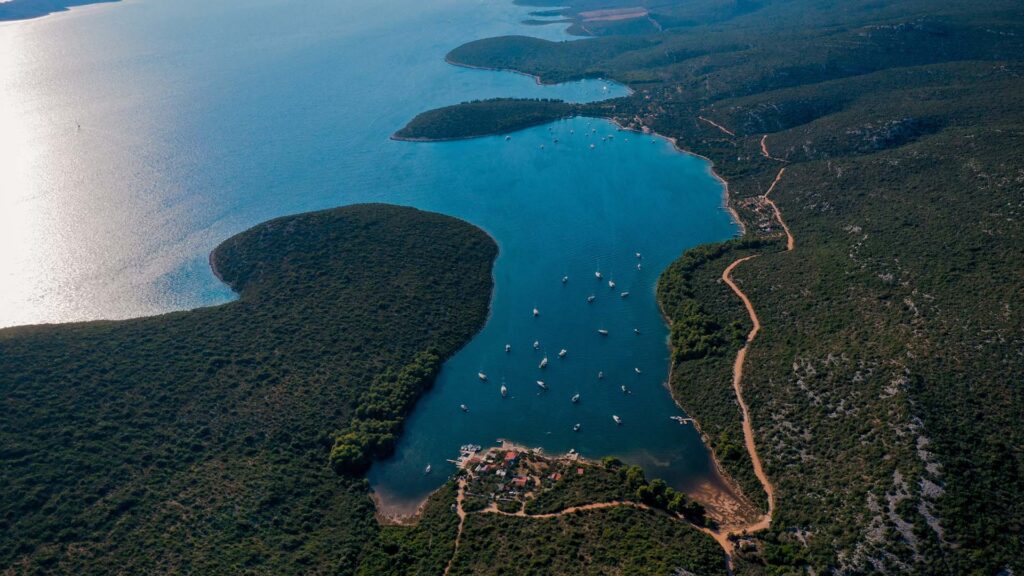
When sailing the island of Rava towards Kornati, the course takes us along the N coast of Dugi otok. Right there is the small town of Luka. Several houses and several berths. Watch out for the numerous shallows and rocks, which are plentiful on this side of Dugi Otok. There is a gas station in Tri Luka, there is enough depth along the pier. Don’t miss a visit to Sali, the largest place on Dugi Otok, the harbor is being renovated, so it is possible that not all berths are available. 4 NM after port sali we reach the end of Dugo Otok (it is 43 km long). Here, according to the navigation plan, we enter the archipelago of the Kornati National Park through the passage of Mala Proversa. The depth is about 5 m, and the passage itself is marked with green and red buoys and must be navigated between. After the passage, the Kornati begin on our left, and on our right another nature park, Telaščica bay, the largest and most sheltered bay on Dugi otok. The port of Telašćica stretches 8 km inside the island, the widest is 1.5 km, and six smaller islets are located in and around it.
In a series of its branches, bays and bays, depending on the winds, there is always a good mooring. Buoys are anchored almost everywhere along the arms of the bay. Along the northern side of Telašćica, which is completely leeward of the storm, the most popular cove is Ćuška Duboka. The sea crept almost a kilometer into the island between the steep, bare rocks. At the bottom of the cove, the sea is only 3 m deep, and there are rocks to watch out for. Most vessels stay in the bay of Mir. As Telašćica is a nature park, a ticket is required to stay inside the cove.
When you sail through the Kornati National Park, do it carefully and with caution, because the archipelago, in addition to its beauty, abounds with many rocks and shoals. So, always have your nautical chart in the cockpit.
Day 4 (Tuesday) Kornati – Soline Bay (Pašman Island) 15 NM
After a morning swim in one of the bays, sail towards the island of Vela Smokvica and exit Kornati through Opatska Vrata. Sail north towards the island of Pašman, but be sure to sail around the island of Žut first. Numerous coves invite you to swim, and there is also the largest port of Žut, where the eponymous ACI marina Žut is located. In addition to the marina, the bay is home to several restaurants that have their own moorings. You can also anchor and climb to the top of Tvrdomesnjak, a hill above the ACI marina from which you can enjoy a beautiful view.
Of course, we can also recommend the island of Žut as a safe anchorage to spend the night. For sailing, staying, anchoring and swimming, the northeast side is more suitable than the other side facing Kornat.
After resting on Žuta, we will sail towards Soline bay on the island of Pašman.
Soline Bay is one of the most beautiful and largest bays on the island of Pašman, located in the neighborhood of the popular St. Ante. Anchoring is allowed, and mooring buoys are also placed in the bay.
In the SE arm of the bay there is shelter from the winds from the I and II quadrants. NW causes chilblains. The NW arm of the cove is protected from NW waves. It can be said that the bay of Soline is a good shelter for all winds.
There are also two restaurants in the bay.
Day 5 (Wednesday) Soline-Molat 28 NM
In the morning, our return to the home marina begins. And we will sail towards the island of Molat and a small islet inside the Brgulj Bay.
On our way we will sail along the island of Iž. On the southern part of the island, in Vodenjak bay, which is closed by the island of Školjić, we can take a break for lunch and swimming. We can anchor or tie up temporarily to a buoy, which is free if we stay up to 2 hours.
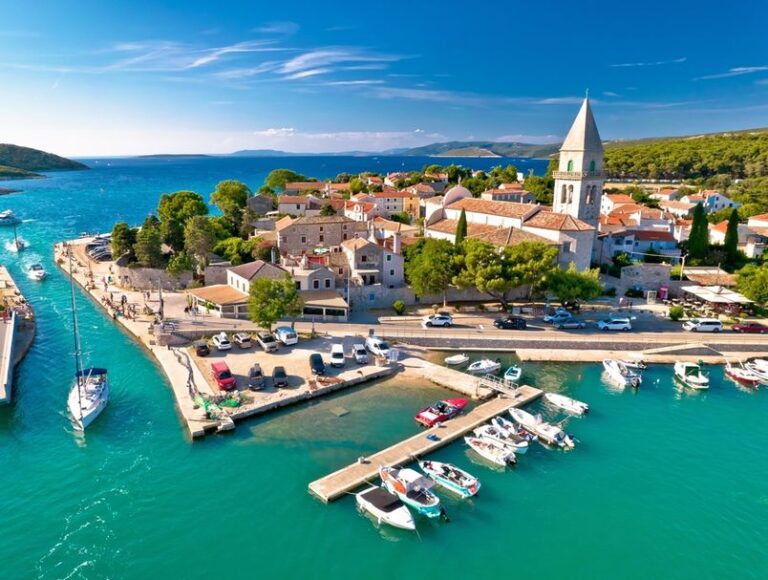
We will sail to the NE side of Iž where, in addition to numerous bays, there is also the island’s main town, Veli Iž, where we can dock for a short time to get groceries. There is also a small marina in Veli Iž.
When we leave the shores of Iž, we have about 12 NM left to reach the Bay of Brgul, that is, the island of Molat.
MOORING:
Anchoring in front of Lucina and Podgarba coves on a sandy bottom that holds well. An organized anchorage with anchored buoys is located in the passage between the islet of Brguljski and the coast of the island of Molat. In the bay of Luka, you can also anchor on the sandy bottom.
Vaz is also possible in the small village of Brgulje on the concrete jetty where moorings have been installed.
There are several bars and restaurants in the village itself. The entire Brgulj Bay is exposed to the SE wind. It is a good shelter from all other winds. A good shelter from the storm is behind the islet opposite the village of Brgulje.
Day 6 (Thursday) Molat-Sakarun Bay (Dugi otok) 12NM
Our sailing is slowly coming to an end and it is important to spend as much time as possible swimming, sailing and exploring.
Our next bay is Sakarun bay.
But before you head there, stop by Božava and tie up at the outer pier or enter the city harbor where the moorings are set up. Use the time to drink coffee and take a walk in the idyllic little Dalmatian village.
The inner part of the harbor behind the breakwater is a perfect shelter from all winds, only when the south gets stronger, you can feel the sea breeze inside the harbor.
After Božava, stick to the shores of Dugi Otok and sail to the extreme NW part, where before the islets of Vela and Mala Lagna there is a wreck of a sunken boat whose mast sticks out of the sea. You can anchor at a depth of 3m and swim to the sunken boat and dive.

On the way to Sakarun, you will sail near the Veli Rat lighthouse, which looks really imposing. From the lighthouse, you are less than an hour away from the bay of Sakarun.
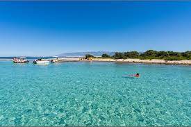
Buoys for mooring have been placed in the bay. You can also anchor, but then you are far from the coast. The sea is turquoise, and you can swim to the shore or use a small boat from the ship. There is sand in the sea, while there are small pebbles on the shore.
There is a small restaurant and a bar in the bay. There are a lot of people on the beach during the day because the beach is not very far from Veli Rat. But that’s why you can enjoy peace and quiet at night. We definitely recommend that you visit this bay.
The bay is protected from all winds except SE.
Day 7 (Friday) Sakarun – Silba 18NM
May our last evening before returning to our home port be magical Silba. A walk around the whole island, dinner in a tavern, make the experience complete.
Set sail in the morning after swimming in the turquoise sea. And then direct the ship through the passage between the islands of Škrda and Ist. You have enough time, so sail to Olib, to the northern bay of Slatinica or to the bay of Sv. Nikola on the SE side of the island.
Olib has several beautiful sandy beaches, so it would be a shame if you are already here not to visit some of them. Now sail NW and go around Olib on the W side, then head for the small harbor on Silba.

MOORING:
Try to find a place to moor on the north side of the island, in a small harbor. It’s Friday and most charter boats are close to their ports or have already returned, so there’s a good chance you’ll find a free berth. If a strong gale is forecast, do not tie up on the N side of the island, but seek shelter in the bay of Sv. Ante where the buoys are anchored. The town of Silba is about a 30-minute walk from the bay.
Dan 8. Silba – ACI marina Šimuni – 12NM
It is only 2 hours of sailing to the ACI marina Šimuni. We are waiting for you around 10 am. Welcome.